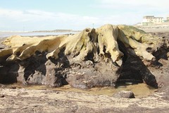
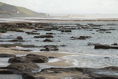
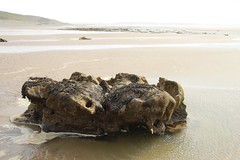
We had a great holiday in Wales last week. Walking the beach from Tywyn to Aberdyfi, we saw how shifting sand has uncovered peat and the remains of 5000 year old trees. The sea level has been falling and rising in this part of Wales since the last ice age. When I was a little boy, my dad told me old stories about how the land in Cardigan Bay was flooded.
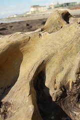
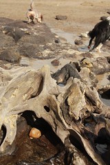
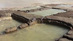
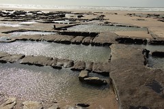
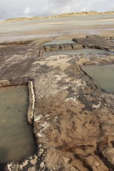
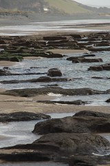
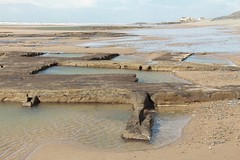
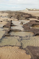
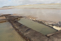
Near Tywyn are places where peat had been dug out as fuel, but further on we came across intricate, repeated patterns that must have taken a lot of time and effort to make.
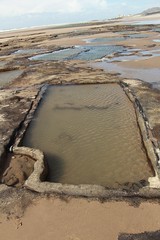
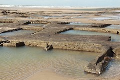
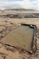
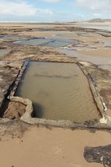
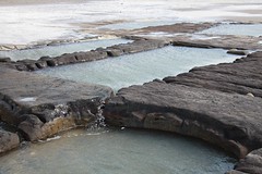

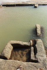
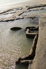
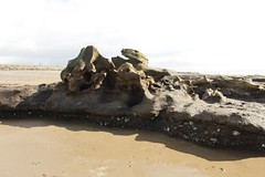
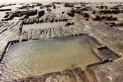
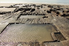
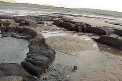
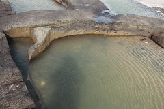
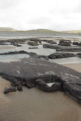
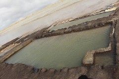
Some of the rectangular pools had gutters cut around them, and others had basin shapes carved in corners. The peat is soft and probably won’t last more than a year or two now that the protective layer of sand has gone.
A google search turned up nothing apart from general talk of the ancient trees, sea level changes and peat extraction. But who cut these shapes ? How long ago did they work ? What was the purpose of all this labour ?
What was all this for ?
That evening I showed the pictures to my father in law, Jim, and he said they looked like salt pans, places where people have worked to make sea salt. That would explain why not much of the peat has been removed, and might account for the gutters and basin shapes. A google search for images of salt pans convinced us that our photos did look like salt pans from all over the world. For instance, the pools have wide walkways between them
Our week long holiday was nearly over and it seemed a pity that we could not find any mention on-line of these delicate shapes cut in the peat, especially because they are being eaten away by the tides.
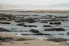
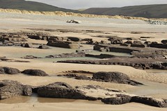
The photos give no sense of the size and layout of the site, it needed to be surveyed from the air.
Drone flight
Cooincidentally, Edward, had a drone for his birthday and what’s more had brought it on holiday to play with. He had not yet managed to control it beyond getting it up and down, let alone use to film anything. So he was sceptical about trying it out on a windy and wet beach, but we set off on a windy afternoon to fly the drone over the beach.
The model took off, rose high over the site before drifting inland. We were nervous that the half charged battery might fail mid air and land the drone in one of the ponds.
Back at the cottage we plugged the SD card into a Mac and saw that the drone had managed to record two of these flights. Suddenly we saw the context of how all the ponds are laid out next to each other.
The video showed that all of the ‘basins’ are on the seaward side of their respective pools. Could they be baffles to stop the ebbing or incoming water from stirring up the salty water ?
A Welsh Salt-Making Venture of the Sixteenth Century
Yet another google search uncovered this paper from 1954, A Welsh Salt-Making Venture of the Sixteenth Century. It describes how four hundred years ago, salt was an expensive commodity needed to preserve meat and fish. The government wanted to reduce imports from France and set out to encourage the development of coastal salt pans. It says;
Cardigan Bay had even then an important herring fishery centred mainly on Aberdovey. The existence of an extensive salt marsh nearby made the prospects of a salt industry even brighter, while the ease with which ships could sail to Ireland was a further attraction, for one of the conditions laid down in the privilege was that enough works be set up to supply that country with salt. The exact location of the works is unknown but the fact that letters were occasionally addressed to ‘Dovie or Abustwith in Cardiganshyre‘ combined with the instructions for the siting of the works, indicate clearly that they were on the south side of the Dovey.
Our site is north of the river Dyfi, not south, but it does meet three key criteria mentioned in the paper. A salt panning site should be;
- inundated by the sea twice a day
- at least 1.5 miles from the nearest river (to avoid diluting the sea !)
- near a fishing port
The beach is mid way between the rivers Dysynni and Dovey.
Are we right ?
So are these historic salt pans ? Are they connected with the lost sites mentioned in the paper ? How old are the ponds ? Who made them ? Are there any wooden structures present ? Has anybody else recorded the site ?
Most of all, should the site be surveyed quickly before it is bashed to bits by the tides ?
We had fun photographing and filming this place, but would love somebody more qualified to investigate its history before it is lost.
Photographs

Gwynedd Archeological Trust – Peat Bed, Tywyn
The record from theGwynedd Archaeological Trust’s database ( search for ‘tywyn peat’) makes no mention of fish farming or salt pans in the peat, nor any structure. It says;
Beneath the beach shingle and dunes is a buried ancient peat-bed, discussed above and Feature 14, below. This is frequently hidden by sand and only visible after particular tide and wind conditions. However, it has been visited previously when exposed (Gwyn and Dutton 1995 and Smith 2002). The peat bed is at least 1m deep and in its surface are many neatly cut rectangular pits, the remains of peat cutting for fuel (Figs 16 & 17). These are so well preserved that spade marks are still visible in some faces. There have been no artefacts to date the pits and no specific historical records of their cutting.
What do you think ?
Let us know
[contact-form-7 404 "Not Found"]